File:Saxicola rubetra, IUCN.png
Jump to navigation
Jump to search

Size of this preview: 800 × 566 pixels. Other resolutions: 320 × 226 pixels | 640 × 453 pixels | 1,024 × 724 pixels | 1,280 × 905 pixels | 2,560 × 1,810 pixels | 3,507 × 2,480 pixels.
Original file (3,507 × 2,480 pixels, file size: 1.22 MB, MIME type: image/png)

|
File:SaxicolaRubetraIUCN.svg is a vector version of this file. It should be used in place of this PNG file when not inferior.
File:Saxicola rubetra, IUCN.png → File:SaxicolaRubetraIUCN.svg
For more information, see Help:SVG. |
 |
Summary
| Description |
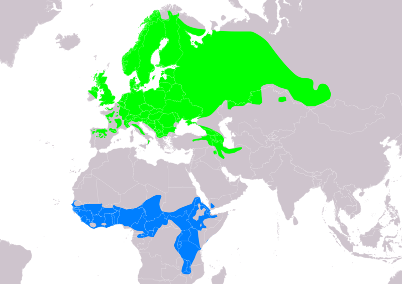
Slovenčina: Mapa rozšírenia druhu pŕhľaviar červenkastý Saxicola rubetra podľa IUCN verzia 2021.3 (zostavil: BirdLife International and Handbook of the Birds of the World (2016) 2016.):
legenda: Hniezdiaci, výskyt v letnom období (#00FF00), Nehniezdiaci (#007FFF) English: Distribution map of whinchat Saxicola rubetra according to IUCN version 2021.3 (compiled by: BirdLife International and Handbook of the Birds of the World (2016) 2016.); key: Legend: Extant, breeding (#00FF00), Extant, non-breeding (#007FFF) |
| Date | |
| Source | Made with Natural Earth. Free vector and raster map data @ naturalearthdata.com. Range map from BirdLife International. 2016. Saxicola rubetra. The IUCN Red List of Threatened Species 2016: e.T22710156A87906903. https://dx.doi.org/10.2305/IUCN.UK.2016-3.RLTS.T22710156A87906903.en. Downloaded on 24 May 2020 as visual indicator of distribution. |
| Author | SanoAK: Alexander Kürthy |
Licensing

This file is licensed under the Creative Commons Attribution-Share Alike 3.0 Unported license.
Attribution: IUCN Red List of Threatened Species, species assessors and the authors of the spatial data.
- You are free:
- to share – to copy, distribute and transmit the work
- to remix – to adapt the work
- Under the following conditions:
- attribution – You must give appropriate credit, provide a link to the license, and indicate if changes were made. You may do so in any reasonable manner, but not in any way that suggests the licensor endorses you or your use.
- share alike – If you remix, transform, or build upon the material, you must distribute your contributions under the same or compatible license as the original.
File history
Click on a date/time to view the file as it appeared at that time.
| Date/Time | Thumbnail | Dimensions | User | Comment | |
|---|---|---|---|---|---|
| current | 17:49, 24 May 2020 | | 3,507 × 2,480 (1.22 MB) | SanoAK | Uploaded a work by SanoAK: Alexander Kürthy from Made with Natural Earth. Free vector and raster map data @ naturalearthdata.com. Range map from BirdLife International. 2016. Saxicola rubetra. The IUCN Red List of Threatened Species 2016: e.T22710156A87906903. https://dx.doi.org/10.2305/IUCN.UK.2016-3.RLTS.T22710156A87906903.en. Downloaded on 24 May 2020 as visual indicator of distribution. with UploadWizard |
File usage
The following page uses this file:
Global file usage
The following other wikis use this file:
- Usage on ar.wikipedia.org
- Usage on arz.wikipedia.org
- Usage on ast.wikipedia.org
- Usage on ba.wikipedia.org
- Usage on bg.wikipedia.org
- Usage on ca.wikipedia.org
- Usage on ceb.wikipedia.org
- Usage on cs.wikipedia.org
- Usage on de.wikipedia.org
- Usage on en.wikipedia.org
- Usage on eo.wikipedia.org
- Usage on es.wikipedia.org
- Usage on eu.wikipedia.org
- Usage on fr.wikipedia.org
- Usage on fy.wikipedia.org
- Usage on ga.wikipedia.org
- Usage on he.wikipedia.org
- Usage on hu.wikipedia.org
- Usage on hy.wikipedia.org
- Usage on id.wikipedia.org
- Usage on ko.wikipedia.org
- Usage on lt.wikipedia.org
- Usage on ml.wikipedia.org
- Usage on nl.wikipedia.org
- Usage on nn.wikipedia.org
- Usage on nv.wikipedia.org
- Usage on os.wikipedia.org
- Usage on pl.wikipedia.org
- Usage on pt.wikipedia.org
- Usage on ru.wikipedia.org
- Usage on sk.wikipedia.org
- Usage on sv.wikipedia.org
- Usage on uk.wikipedia.org
- Usage on www.wikidata.org